Metro Area Stations |
Morgan Boulevard Metrorail Station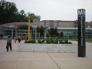
Station Area Vision This station opened for service in late 2004. The 2004 Morgan Boulevard-Largo Town Center sector plan encourages an attractive, quality mixed-use transit center with mid-rise multifamily, townhouses, office and local retail uses. Significant single-family and multifamily residential development has taken place to the north and east of the station since its opening. Morgan Boulevard Metrorail Station
The land uses planned within one-half mile of the Metro station are mixed-use office, multifamily residential, and townhomes. The 2004 Approved Sector Plan and Sectional Map Amendment for the Morgan Boulevard and Largo Town Center Metro Areas is the applicable sector plan for this station. Sites in Public Ownership WMATA owns 25.0 acres including the station and parking area. 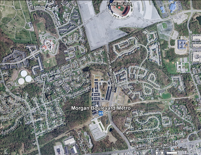 Quick Facts (WMATA Data 2010)
 The Central Avenue-Metro Blue Line Corridor TOD Implementation Project includes two distinct but overlapping areas. The first area consists of properties between the District of Columbia and Daimler Drive included within the Capitol Heights Transit District Overlay, the Addison Road Town Center and Vicinity SMA Development District Overlay, and the proposed Addison Road Regulating Plan. It reflects the program’s emphasis on promoting transit-oriented development, high-quality urban design, and station accessibility around the Capitol Heights and Addison Road-Seat Pleasant Metro Stations while strengthening neighboring residential communities. The second area is broader, extending along Central Avenue from the District of Columbia to the Largo Town Center Metro Station within a half-mile radius of Central Avenue, to allow the program to comprehensively examine the Metro Blue Line corridor, forge a clear marketing and economic development campaign, and support business attraction and retention efforts. The Central Avenue-Metro Blue Line Corridor TOD Implementation Project includes two distinct but overlapping areas. The first area consists of properties between the District of Columbia and Daimler Drive included within the Capitol Heights Transit District Overlay, the Addison Road Town Center and Vicinity SMA Development District Overlay, and the proposed Addison Road Regulating Plan. It reflects the program’s emphasis on promoting transit-oriented development, high-quality urban design, and station accessibility around the Capitol Heights and Addison Road-Seat Pleasant Metro Stations while strengthening neighboring residential communities. The second area is broader, extending along Central Avenue from the District of Columbia to the Largo Town Center Metro Station within a half-mile radius of Central Avenue, to allow the program to comprehensively examine the Metro Blue Line corridor, forge a clear marketing and economic development campaign, and support business attraction and retention efforts.
Subregion 4 (Central Avenue-Metro Blue Line Corridor) TOD Implementation Project  Subregion 4 (Central Avenue-Metro Blue Line Corridor) TOD Implementation Project
The Subregion 4 Transit-Oriented Development Implementation Project will put into effect the vision and goals for the Central Avenue corridor as presented in the recently approved 2010 Subregion 4 Master Plan and Sectional Map Amendment and will advance the recommendations of the 2008 Capitol Heights Transit District Development Plan and Transit District Overlay Zoning Amendment. These plans envision mixed-use, transit-oriented development and promote housing and neighborhood conservation, public facility and infrastructure improvements, and commercial revitalization. In 2010-2011, the project will focus on Capitol Heights and Addison Road Seat Pleasant Metro Stations and during 2011-2012 the project will concentrate on Largo Town Center & Morgan Boulevard Metro Stations. Read more about this plan 
Approved Sector Plan and Sectional Map Amendment for the Morgan Boulevard and Largo Town Center Metro Areas (May 2004) This document contains text and maps of the Approved Sector Plan and Sectional Map Amendment for Morgan Boulevard and Largo Town Center Metro Areas. The plan will amend portions of the 1993 Approved Master Plan and Sectional Map Amendment for Landover and Vicinity, the 1990 Approved Master Plan Amendment and Adopted Sectional Map Amendment for Largo-Lottsford, and the 1986 Approved Master Plan and Adopted Sectional Map Amendment for Suitland-District Heights and Vicinity. Developed by the Commission, with the assistance of the community, this document describes existing plans and policies for the area; analyzes land use, zoning, environment, population, urban design and public facilities; and proposes flexible land use and zoning regulations to promote transit-oriented development in proximity to the Morgan Boulevard and Largo Town Center Metro Stations. The document includes a sectional map amendment (SMA), a Development District Overlay Zone (DDOZ) containing design standards and a table of uses. These zoning tools will implement the plan's land use and community character recommendations. |

