Metro Area Stations |
Capitol Heights Metrorail Station
Station Area Vision The General Plan designates this station area as a Community Center. Community Centers are concentrations of activities, services and land uses that serve the immediate community. These typically include a variety of public facilities and services, integrated commercial, office and residential development, and can include mixed-use and higher intensity redevelopment. The most intensive development should occur in close proximity to the Metro station with less intensive development radiating out to the edges. Capitol Heights Metrorail Station
The land uses planned within one-half mile of the Metro station are commercial, retail, office, ad single-family units. The Capitol Heights TDDP and Endorsed Transit District Overlay ZMA (2008) is the applicable master plan for this Metro station area. Sites in Public Ownership WMATA owns 6.11 acres including the station and parking area. The Town of Capitol Heights owns approximately 10 acres within one-quarter mile of the station. 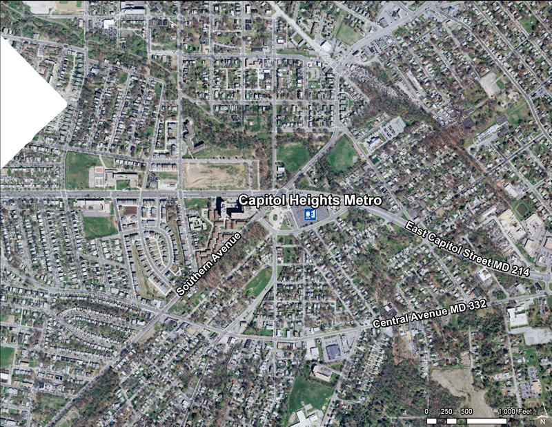 Quick Facts (WMATA Data 2010)
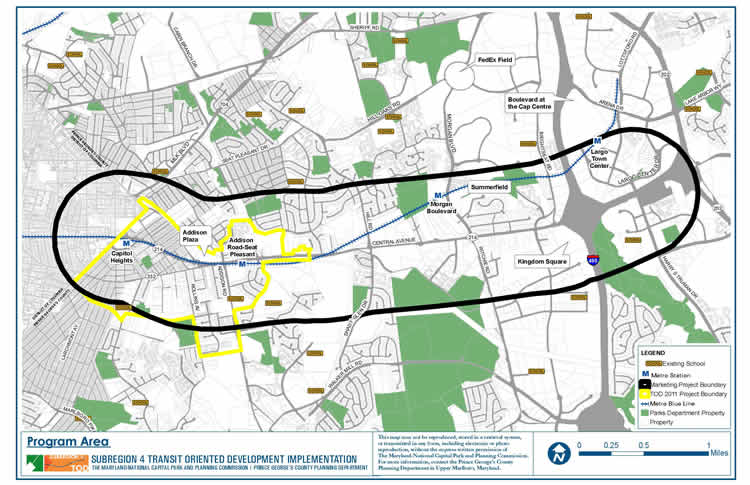
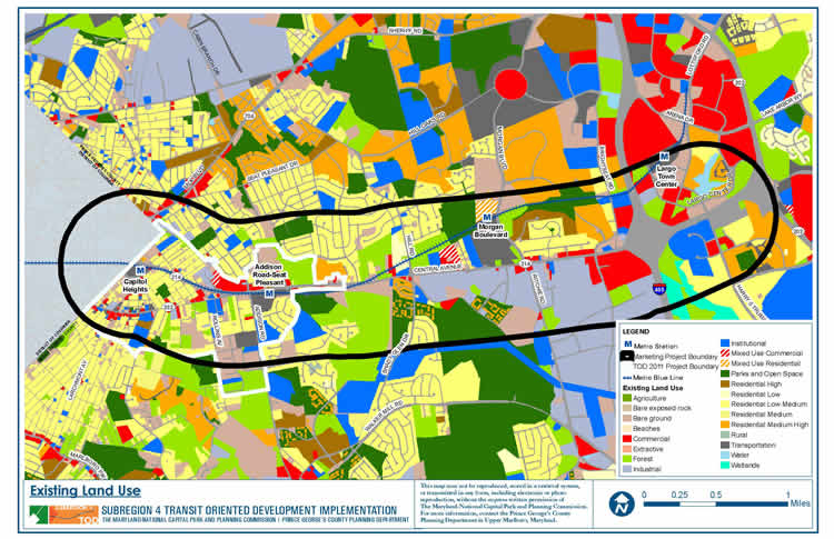
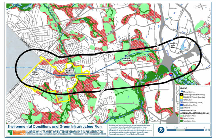
 The Central Avenue-Metro Blue Line Corridor TOD Implementation Project includes two distinct but overlapping areas. The first area consists of properties between the District of Columbia and Daimler Drive included within the Capitol Heights Transit District Overlay, the Addison Road Town Center and Vicinity SMA Development District Overlay, and the proposed Addison Road Regulating Plan. It reflects the program’s emphasis on promoting transit-oriented development, high-quality urban design, and station accessibility around the Capitol Heights and Addison Road-Seat Pleasant Metro Stations while strengthening neighboring residential communities. The second area is broader, extending along Central Avenue from the District of Columbia to the Largo Town Center Metro Station within a half-mile radius of Central Avenue, to allow the program to comprehensively examine the Metro Blue Line corridor, forge a clear marketing and economic development campaign, and support business attraction and retention efforts. The Central Avenue-Metro Blue Line Corridor TOD Implementation Project includes two distinct but overlapping areas. The first area consists of properties between the District of Columbia and Daimler Drive included within the Capitol Heights Transit District Overlay, the Addison Road Town Center and Vicinity SMA Development District Overlay, and the proposed Addison Road Regulating Plan. It reflects the program’s emphasis on promoting transit-oriented development, high-quality urban design, and station accessibility around the Capitol Heights and Addison Road-Seat Pleasant Metro Stations while strengthening neighboring residential communities. The second area is broader, extending along Central Avenue from the District of Columbia to the Largo Town Center Metro Station within a half-mile radius of Central Avenue, to allow the program to comprehensively examine the Metro Blue Line corridor, forge a clear marketing and economic development campaign, and support business attraction and retention efforts.
Subregion 4 (Central Avenue-Metro Blue Line Corridor) TOD Implementation Project  Subregion 4 (Central Avenue-Metro Blue Line Corridor) TOD Implementation Project
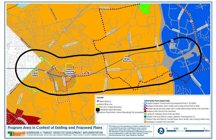
The Subregion 4 Transit-Oriented Development Implementation Project will put into effect the vision and goals for the Central Avenue corridor as presented in the recently approved 2010 Subregion 4 Master Plan and Sectional Map Amendment and will advance the recommendations of the 2008 Capitol Heights Transit District Development Plan and Transit District Overlay Zoning Amendment. These plans envision mixed-use, transit-oriented development and promote housing and neighborhood conservation, public facility and infrastructure improvements, and commercial revitalization. In 2010-2011, the project will focus on Capitol Heights and Addison Road Seat Pleasant Metro Stations and during 2011-2012 the project will concentrate on Largo Town Center & Morgan Boulevard Metro Stations. Read more about this plan

Approved Capitol Heights Transit District Development Plan and Transit District Overlay Zoning Map Amendment (July 2008) This document contains text and maps of the approved transit district development plan (TDDP) and transit district overlay zoning map amendment for the Capitol Heights Metro Station and vicinity. This plan contains a new TDOZ and transit district overlay zone (TDOZ) and amends portions of the 1993 Approved Master Plan and Sectional Map Amendment for Landover and Vicinity (Planning Area 72) and the 1986 Approved Master Plan for Suitland-District Heights and Vicinity, Planning Areas 75A and 75B. Developed by M-NCPPC with the assistance of the community, this plan contains a comprehensive development vision, development review process requirements, and form-based development standards and guidelines. Together, these elements comprise the Capitol Heights Transit District Development Plan (TDDP). It controls and guides the use and development of all land within the Transit District Overlay Zone (TDOZ) from the initial submittal of plans to the issuance of permits. Together, the TDOZ and TDDP are intended to foster transit-oriented development that increases the use of public transit, maximizes return on investment in transit facilities and services, encourages appropriate development near transit stations with coordinated urban design elements, and increases local tax revenues.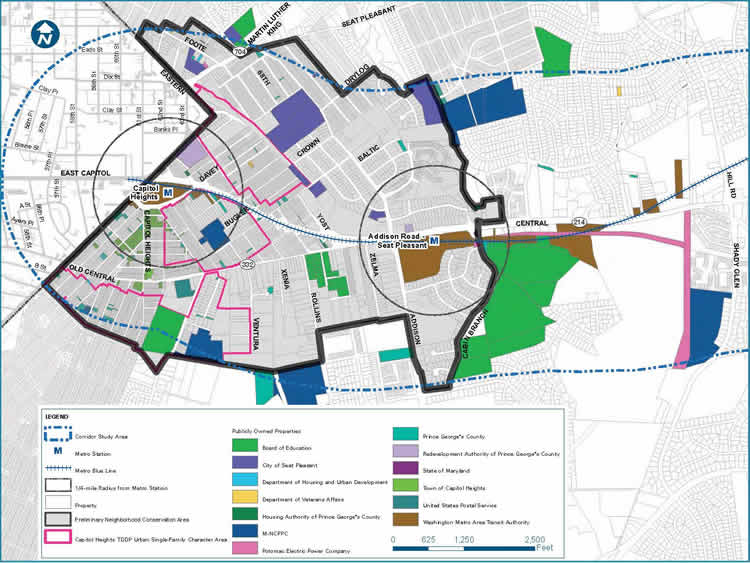
City of Seat Pleasant – The City of Seat Pleasant is adjacent to the eastern corner of the District of Columbia, north of East Capitol Street/Central Avenue.
|