The plan includes a mixed-use center
including mid-rise residential, office, and research uses. Major tenants include the Food and Drug Administration, the United States Department of Agriculture, the National Oceanic and Atmospheric Administration, and the American Center for Physics. M Square, The University of Maryland’s Enterprise Campus, is located on 128 acres of university property here. The Center for the Advanced Study of Language is the first tenant of this future research and business campus.
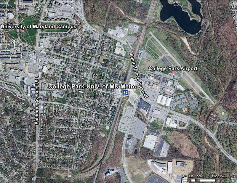
College Park/UM Metrorail Station
Located at the intersection of Paint Branch Parkway and the CSX railroad tracks.
There is a 100-year floodplain within one-half mile of the station: 97 acres of floodplain, 12 acres of nontidal wetlands, and
93 acres of woodlands.
The nearest community is the City of College Park.
The General Plan places this station in the Developed Tier and classifies it as a Metropolitan Center.
This station area is located within a transit-district overlay zone (TDOZ).
Access is via Baltimore Avenue (US 1), Kenilworth Avenue (MD 201), River Road, and Paint Branch Parkway.
Summary of Allowable Uses
The land uses planned within one-half mile of the station are mixed-use office, retail, hotel, light industrial and recreation. The College Park-Riverdale Transit District Development Plan (1997) is the applicable sector plan for this Metro station.
Sites in Public Ownership
WMATA owns 260 acres including the station and parking area. The State of Maryland owns 111 acres of permanent open space
land within one-half mile of the station.
Quick Facts (WMATA Data 2010)
Transit Ridership:
5,322 entries
5,044 exits
Transit:
8 Metrobus routes
1 THE BUS route
2 MTA commuter bus routes
Parking:
3,072-space surface lot
150-space metered surface lot
Bike Parking:
There are 81 bike racks and 40 lockers available at this station
College Park – University of Maryland is a Washington Metro station in Prince George's County, Maryland on the Green Line.
The station is located in College Park near the University of Maryland, College Park, with entrances at the intersection of Calvert Road and Bowdoin Avenue, and near the intersection of Paint Branch Parkway and River Road. It adjoins the headquarters of the American Physical Society and the Food and Drug Administration (FDA). Service began on December 11, 1993.
Approved Transit District Development Plan for the College Park-Riverdale Transit District Overlay Zone (October 1997)
This document contains maps, figures, tables and supporting text for the Approved College Park-Riverdale Transit District Development Plan (TDDP). This plan controls and guides the use and development of all land and the issuance of all permits in the designated Transit District Overlay Zone (TDOZ). This plan constitutes an amendment to the Prince George's County Zoning Map for that portion of Planning Areas 66 and 68 described as the College Park-Riverdale Transit District. The plan, initiated through a County Council Resolution (CR- 1 141 989). was developed by the Maryland-National Capital Park and Planning Commission with input from citizen groups in adjacent communities and from municipalities, local and State agencies and property and business owners within the proposed transit district. It was approved by the Prince George's County Council on October] 4, 1 997, via Zoning Ordinance No. 35- 1 997. The approved TDDP presented in this document is designed to promote coordinated and integrated development within the TDOZ. The TDDP changes the zoning and describes mandatory regulations and guidelines for new development regarding urban design, transportation, parking, natural resources and public facilities. In addition, it describes infrastructure improvements.
The Purple Line Project
Planning for the Purple Line, light rail station at College Park and the joint development project has been an ongoing collaborative effort involving Maryland Transit Administration (MTA), Metro, the private development team, Prince George’s County and College Park for several years. An alignment of the Purple Line across the Metro station property has been agreed upon by Metro, State, County, and Developer representatives. However, final details regarding the location of platforms and pedestrian connections still remain to be determined.

 Quick Facts (WMATA Data 2010)
 College Park – University of Maryland is a Washington Metro station in Prince George's County, Maryland on the Green Line.
 The Purple Line Project