Metro Area Stations |
Addison Road Metrorail Station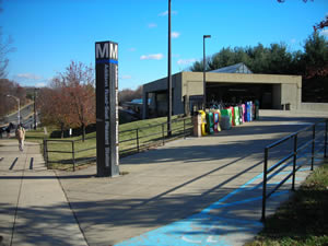
Station Area Vision Transit-friendly land uses are encouraged by the plan in this town center. Flexible zoning, land use and design controls allow for compact, mixed uses consisting of professional offices, retail shopping, service commercial, a town green, public meeting facilities, and single-family and multifamily units within easy walking distance of this station. Addison Road Metrorail Station
The land uses planned within one-half mile of the Metro station are commercial, office, and retail. The Addison Road Metro Town Center Sector Plan (2000) is the applicable master plan for this Metro station area. Sites in Public Ownership WMATA owns12.0 acres including the station and parking area. The County’s Redevelopment Authority owns approximately 21 acres of residentially zoned land within one-half mile of the station and 2 acres of mixed-use zoned land directly across from the station. 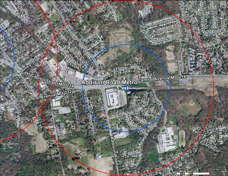 Quick Facts (WMATA Data 2010)
 The Central Avenue-Metro Blue Line Corridor TOD Implementation Project includes two distinct but overlapping areas. The first area consists of properties between the District of Columbia and Daimler Drive included within the Capitol Heights Transit District Overlay, the Addison Road Town Center and Vicinity SMA Development District Overlay, and the proposed Addison Road Regulating Plan. It reflects the program’s emphasis on promoting transit-oriented development, high-quality urban design, and station accessibility around the Capitol Heights and Addison Road-Seat Pleasant Metro Stations while strengthening neighboring residential communities. The second area is broader, extending along Central Avenue from the District of Columbia to the Largo Town Center Metro Station within a half-mile radius of Central Avenue, to allow the program to comprehensively examine the Metro Blue Line corridor, forge a clear marketing and economic development campaign, and support business attraction and retention efforts. The Central Avenue-Metro Blue Line Corridor TOD Implementation Project includes two distinct but overlapping areas. The first area consists of properties between the District of Columbia and Daimler Drive included within the Capitol Heights Transit District Overlay, the Addison Road Town Center and Vicinity SMA Development District Overlay, and the proposed Addison Road Regulating Plan. It reflects the program’s emphasis on promoting transit-oriented development, high-quality urban design, and station accessibility around the Capitol Heights and Addison Road-Seat Pleasant Metro Stations while strengthening neighboring residential communities. The second area is broader, extending along Central Avenue from the District of Columbia to the Largo Town Center Metro Station within a half-mile radius of Central Avenue, to allow the program to comprehensively examine the Metro Blue Line corridor, forge a clear marketing and economic development campaign, and support business attraction and retention efforts.
Subregion 4 (Central Avenue-Metro Blue Line Corridor) TOD Implementation Project  Subregion 4 (Central Avenue-Metro Blue Line Corridor) TOD Implementation Project
The Subregion 4 Transit-Oriented Development Implementation Project will put into effect the vision and goals for the Central Avenue corridor as presented in the recently approved 2010 Subregion 4 Master Plan and Sectional Map Amendment and will advance the recommendations of the 2008 Capitol Heights Transit District Development Plan and Transit District Overlay Zoning Amendment. These plans envision mixed-use, transit-oriented development and promote housing and neighborhood conservation, public facility and infrastructure improvements, and commercial revitalization. In 2010-2011, the project will focus on Capitol Heights and Addison Road Seat Pleasant Metro Stations and during 2011-2012 the project will concentrate on Largo Town Center & Morgan Boulevard Metro Stations. Read more about this plan  Addison Road Metro Area Approved Sector Plan and Sectional Map Amendment (October 2000)
This document contains text and maps of the Approved Sector Plan and Sectional Map Amendment for the Addison Road Metro Town Center and Vicinity. The plan amends portions of the 1985 Suit/and-District Heights and Vicinity Master Plan and the 1993 Landover and Vicinity Master Plan. The plan is also an amendment to the General Plan for the Maryland-Washington Regional District within Prince George's County, Maryland, approved by the County Council in 1982. Developed by the community with the assistance of the Commission, this document discusses existing plans for the area, and analyzes population, employment, land use, and zoning characteristics. The sector plan proposes a town center for the area surrounding the Metro station, and sets forth concepts and recommendations for land use, access and circulation, and urban design. The document includes the approved sectional (zoning) map amendment which implements the land use recommendations of the plan for the town center. The approved Development District Standards are also included. Proposals for improvement of the surrounding community address property standards, public facilities, environmental protection, image, amenities, redevelopment initiatives, and Old Town Seat Pleasant. Read more about this plan |

