This center features a distinct, integrated
and inviting mixed-use community of retail, office, entertainment and residential uses that achieve a high-intensity 24-hour environment, while preserving and protecting two major tributaries of the Anacostia River. The plan calls for improved access to the Capital Beltway, two mixed-use developments in the core area, and a transit village with distinct neighborhoods based on neo-traditional planning concepts.
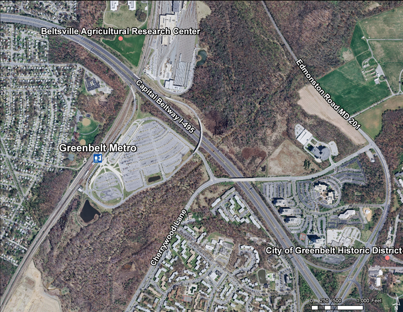
Greenbelt Metrorail Station
Located at the intersection of Cherrywood Lane and the Capital Beltway (Interstate 95/495).
There are wetlands and floodplain environmental conditions on the station site.
The nearest communities are City of Greenbelt, Town of Berwyn Heights, and residential communities of Hollywood and Springhill Lake.
The General Plan places this station in the Developed Tier and classifies it as a Metropolitan Center.
The station area is within a development district overlay zone (DDOZ).
Access is via the Capital Beltway (Interstate 95/495), Kenilworth Avenue (MD 201), Greenbelt Road (MD 193), and Cherrywood Lane.
Summary of Allowable Uses
The land uses planned within one-half mile of the Metro station are mixed-use retail, office, entertainment, and residential. The
Greenbelt Metro Area Approved Sector Plan and Sectional Map Amendment (October 2001) is the applicable master plan for this Metrorail station area.
Sites in Public Ownership
WMATA owns 260 acres including the station and parking area. The State of Maryland owns 111 acres of permanent open space
land within one-half mile of the station.
Quick Facts (WMATA Data 2010)
Transit Ridership:
7,237 entries
7,102 exits
Transit:
8 Metrobus routes
1 THE BUS route
2 MTA commuter bus routes
Parking:
3,072-space surface lot
150-space metered surface lot
Bike Parking:
There are 60 bike racks and 52 lockers available at this station
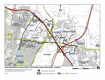
Greenbelt Metro Area and MD 193 Corridor Sector Plan and SMA
The Prince George's County Council, sitting as the District Council, initiated the Greenbelt Metro Area and MD 193 Corridor Sector Plan and Sectional Map Amendment (SMA) on May 17, 2011 (see CR-40-2011). This planning effort will follow the 18-month planning process established by the County Council in 2005.
Preplanning and initial discussions with residents, employees, business and property owners, agency staff, municipal leaders, and other key stakeholders began in the fall of 2010 to help the project team further define the project and establish sector plan boundaries. This initial phase of outreach is being followed by a number of community and stakeholder meetings and workshops in the summer and fall of 2011. These sessions will result in the creation of a consensus vision and plan for the future development and design character for the Greenbelt Metro area and MD 193 corridor.
Greenbelt Metro Area Approved Sector Plan and Sectional Map Amendment (October 2001)
This document contains text and maps of the Approved Greenbelt Metro Area Sector Plan and Sectional Map Amendment. The plan amends the 1989 Approved Langley Park-College Park-Greenbelt Master Plan and the 1990 Approved Subregion Master Plan. The plan is also an amendment to the General Plan for the Maryland-Washington Regional District within Prince George=s County, Maryland, approved by the County Council in 1982. Developed by the Commission with the assistance of the sector planning group, the plan discusses existing plans and growth policies and analyzes land use, circulation, environment, cultural heritage, recreation and open space, public facilities, economics and market, and zoning characteristics. The plan sets forth goals, concepts, recommendations and design standards and/or guidelines for the entire Sector Plan Area and each subarea. The Sectional Map Amendment section contains zoning changes including an overlay zone to implement the plan=s land use recommendations and design standards.
Greenbelt Metro Area and MD 193 Corridor Sector Plan and SMA
The Prince George’s County Planning Department of The Maryland-National Capital Park and Planning Commission (M-NCPPC) is conducting a planning project to shape future growth and development in the Greenbelt Metro area and along the Greenbelt Road/MD 193 Corridor. The goal of this project is to develop an innovative approach to achieving the goals of the 2002 Prince George's County Approved General Plan for metropolitan centers and corridors to comprehensively reevaluate the area’s zoning and land use policy, transportation, and environmental issues to foster a transit-oriented, mixed-use environment compatible with surrounding communities.

 Quick Facts (WMATA Data 2010)